Modern Plan Of The City And Environs Of Dublin 1798
Click The Map Image Above To View Enlarged Sections
The Map
| Full Title: |
To Her Excellency Frances Countess Camden, &c &c &c. This MODERN PLAN of the City and Environs of DUBLIN. Including the Grand & Royal Canals, New Docks, &c. Is by Permission, most respectfully Inscribed by her Ladyship's humble & obedient Servant, Wm Wilson. |
|
| Map Maker: |
|
| Date: |
Published as the Act directs for W. Wilson & sold by the Booksellers and Printsellers in London & Dublin, June 1st ~ 1798. |
| Engraver: |
|
| Publisher: |
|
| Size: |
56.5cm x 47.5cm (22¼" x 18¾"). |
| Scale: |
3½" : ½ Irish Mile |
| Extent: |
Richmond - Ringsend - Mt Pleasant - Phoenix Park. |
| Description: |
Shows existing and intended buildings, County Boundaries, North and South Divisions, and the Earl of Meath's Liberty. Compass Star top centre. Inset view of the New Custom House bottom left. Scale of half a Mile Irish bottom left. Dublin City Coat Of Arms, with The Great Mace (1665) and the Great Civic Sword (1390s) bottom right. Explanation (reference)
table bottom right.
|
| |
Note that the proposed Royal Circus in Dublin (Architect: Thomas Cunningham) shown on this map was never built.
The map includes the following Explanation:
I. The river separates the Nth & Sth Divisions of the City as regulated by a late Act of Parliament no other distinction correct.
II. The Buildings ................ Red Wash
III. Intended Do ................ Faint do.
IV. County Boundaries ...... Blue Line
V. Earl of Meath's Liberty... Green do.
The dedication is to Frances, Countess Camden (daughter of William Molesworth of Wembury, Devonshire, England), wife of John Jeffreys Pratt, 2nd Earl of Camden (1759-1840), later 1st Marquis of Camden, who was Lord Lieutenant of Ireland from 31 March 1795 until late June 1798.
|
|

Place Name Search Feature
This map includes a comprehensive search feature for place names. The search feature is located at the top right of each page, with a search box containing the words "Search This Map". The Search Engine enables a targeted search of the 1798 map of Dublin.
You can start your search of the map of Dublin here:
The Search Engine has also compiled a Complete Index Of Dublin Place Names, which is well worth referring to.
Please note that this is not a general search engine for the entire MAPCO website, but is targeted specifically at the map currently being viewed. The entire MAPCO site can be searched using the Google Search Engine on the Search Help page.
How To Use These Map Pages
Use the thumbnail map at the top of each page to navigate your way around the map.
Hovering your mouse pointer over the thumbnails will highlight the individual sections, and display a pop-up message showing the areas covered by that section of the map. Click the desired area to jump to a page displaying a full size image of the map section. You will need to scroll down the page a little to see the image of the map.
A coloured thumbnail image on the thumbnail map at the top of the page will show you which section of the entire map you are currently viewing.
Click To Enlarge
Once you are viewing the desired map section, you can click on the map image to view an enlarged image of that section.
Clicking on the map images allows you to switch back and forth ('toggle') between the normal sized image and the enlarged view of the section.
Historical Background
|
John Jeffreys Pratt, 2nd Earl of Camden. Lord Lieutenant of Ireland 1795-1798.
John Jeffreys Pratt, 1st Marquis of Camden, was extremely unpopular in Ireland for repressing Roman Catholic representation in the Irish Parliament. Implementation of repressive policies by Camden contributed to the Irish Rebellion of 1798 (or United Irishmen Rebellion) that began on May 23 in the districts surrounding Dublin. The rebellion was suppressed by late June with the pivotal defeat of the
South Leinster rebels at Vinegar Hill (Co. Wexford) on June 21. In the aftermath of the rebellion Camden resigned his post of Lord Lieutenant of Ireland and retreated to London.
It is interesting to note that this map, dated 1st June 1798, falls right in the middle of the Irish Rebellion, and would have been one of the last acknowledgements bestowed upon the Camdens in Dublin before Pratt's resignation as Lord Lieutenant of Ireland.
William Wilson, Bookseller And Stationer, Dublin, Ireland.
The honour bestowed to Frances Countess Camden by the dedication of this map would have been in response to her patronage for the project.
The map maker, William Wilson (fl. 1769-1801), appears to have been an established publisher of travel guides, directories and almanacks in Dublin, including Wilson's Dublin Directory, For The Year 1780 and The Post Chaise Companion Or A Traveler's Directory Through Ireland (Dublin, 1784). Wilson is recorded as a bookseller and stationer at No. 6, in Dame-Street, the corner of Palace-Street,
Dublin. |
|
Of note in reference to the map displayed here is Wilson's Dublin Directory For The Year 1798 : Including The Additions And Corrections Of The Bank Of Ireland : Containing An Alphabetical List Of The Names, Occupations, And Places Of Abode Of The Merchants, And Traders Of The City Of Dublin.
A Peter Wilson was a bookseller in Dame Street, Dublin, from the 1750s on, his publications including the Dublin Magazine. He published the first trade directories in Ireland, starting with Dublin in 1751 (An Alphabetical List of the Names and Places of Abode of the Merchants and Traders of the City of Dublin, included in The Treble Alma). It is probable that Peter was the
father of William Wilson.
Benjamin Baker, Map Engraver And Publisher, Islington, London, England.
Benjamin Baker (1766-1841 : fl. 1790s-1824) was a prolific producer of engraved maps from the late 18th century onwards.
Baker's engraving work is found in association with many famous map makers of the era, including William Faden, Geographer to the King, Laurie & Whittle, and others. In the 1790s Baker's work included maps of the Southern Hemisphere, charts of voyages of exploration, canal maps, and foreign views. During this period Baker resided at 32 High Street, Islington (1791-1793), and later in Lower Street,
Islington (1798-1800).
Baker's trade card reads:
Benj Baker
Engraver
No 32
High Street
Islington
----------------------------
N.B. Maps, Charts, &c.
Accurately Engraved.
In the early 1800s Baker became the engraver to the Board of Ordnance at the Tower of London, helping to produce the first 1" inch Ordnance Survey maps, published by Lt. Col. Mudge, Tower.
Evan and Thomas Williams, Printers And Booksellers, Strand, London, England.
The publishers and map sellers, E. & T. Williams (brothers Evan and Thomas Williams), were printers and booksellers in the Strand, London, England from 1787 onwards, who sold books to their Royal Highnesses the Duke and Duchess of York 1803-1809.
Their predecessor, Richmond Blamire, was a bookseller and stationer, who was situated on the corner of Craven Street & Strand. At some stage in the late 1700s Blamire "Removed from Craven Street, to the Corner of Northumberland Street, Strand". It is likely that this is where the brothers were trading from when the map of Dublin was published in 1798.

New Custom House
James Gandon, Architect.
The New Custom House, built on the north bank of the Liffey was designed by the English architect James Gandon. Construction commenced in 1781, with the opening a decade later, on 7th November 1791. The building cost a staggering £200,000 to construct, the cost of which made Gandon a very unpopular figure at the time.
Like the Earl of Camden, Gandon fled Dublin during the The Irish Rebellion of 1798 (Éirí Amach 1798), returning to London where he was born. When the rebellion was suppressed, Gandon returned to Dublin and continued his career as an architect there, vastly influencing the look of the city.
|


, Clarke Bridge, Royal Canal, & Newcomen Bridge")
, & Ballybough River At Low Water")
, Circular Road, Road From Castlenock, & Royal Infirmary")


, Amiens Street, Gloucester Place (Gloster Place), Mecklenburgh Street, Dominick Street, Great Britain Street, Denmark Street, Market, Coles Lane, Simpsons Lane, Henry Street, Moore Street, Off Lane, Moore Lane, Sackville Street, Gregs Lane, St Thomas, Stable Lane, Marlborough Street, Elephant Lane, Earl Street, Stable Lane, Tuckers Row, Tyrone House, Cope Street, Marlborough Green (Marlboro Green), Blenham Street, Abbey Street, Gardiner Street, Mabbot Street, Montgomery Street, Moland Street, Liffey Street, Lower Liffey Street, Princes Street, The Lots, Batchelors Walk, Lower Abbey Street, Union Street, Dry Dock, Beresford Place, Custom House, Dock, River Anna Liffey, Carlisle Bridge, Astons Quay, Hawkin Street, Georges Quay, Poolbeg Street, Georges Street, Luke Street, Moss Street, City Quay, Gloster Street, & Princes Street")
, Amiens Street, The Strand, Sheriff Street, Mayor Street, Commons Street, Guild Street, Wapping Street, North Wall, River Anna Liffey, City Quay, Gloster Street, Sir John Rogersons Quay, Lombard Street, Ordinance Street, Windmill Lane, Kings Stores, Marine School, Great Clarence Street, & Forbes Street")

, Road From Chapclizod, Salute Battery, Conyngham Road, River Anna Liffey, Sarah Bridge, Island Bridge, St John's Well, Burial Ground, Royal Hospital, Kilmainham New Gaol, Gaolers House, Inchicore Road, Road From Naas, Old Gaol, Kilmainham, Kilmainham Lane, Circular Road, & Grand Canal")
, Gate, Park Gate Street, Long Meadows, Barrack Street, Flood Street, Liffey Street, Sand Quay, Sliver Street, River Anna Liffey, Barrack Bridge, Slip, Stevens Lane, Stevens Hospital, Mill Race, Galway Walk, Cooks Lane, Watling Street, Ushers Island, Island Street, Bonham Street, Four Court Marshalsea, Mass Lane, Bow Bridger, Bow Lane, St Patricks Hospital, Mt Brown, James's Street, Workhouse, Bason Lane (Basin Lane), City Bason (City Basin), Fountain, St James's Church, Soldiers Hospital, Echlin Lane, Canal Place, Canal Harbour, Portland Street, Market House, Robert Street, Ransford Street, Cherrytree Lane, James's Gate, Thomas Street, Crane Lane, Belview Lane, Taylors Lane, Cryllis Yard, Grand Canal, City Water Course, Marrow Bone Lane, Tenter Fields, Cork Street, Dolphins Barn Lane, & Love Lane")
, Stable Lane, Arran Quay, Lincolns Lane, Bow Lane, St Michaels Church, Hammond Lane, Old Church Street, Greek Street, Bull Lane, Fishers Lane, Pill Lane, New 4 Courts & Public Offices, Moro'n Place, Kings Inn Quay, Monmath Street, Charles Street, Ormond Mews, Arran Street, Upper Ormond Quay, Marys Abbey, Capel Street, Great Strand Street, Lower Ormond Quay, River Anna Liffey, Queens Bridge, Old Bridge, Ormond Bridge, Essex Bridge, Ushers Island, Island Street, Bonham Street, Four Court Marshalsea, Mass Lane, Mash Lane, Thomas Street, Bridge Foot Street, Bridge Foot, Ushers Quay, Ushers Lane, Usher Street, Dog & Duck Yard, Ushers Court, Allen Court, Wormwood Gate, Mullinahack, John Street, New Row, Market House, Bridge Street, Merchants Quay, Church, Swan Alley, Skippers Lane, Chapel Yard, Rosemary Lane, Winetavern Street, Upper Bridge Street, Cutpairse Row (or Curpurse Row), Corn Market, Kelzars Lane (or Keizars Lane), Audeons Arch (St Audoen's Arch), Audeons Church (St Audoen's Church), Schoolhouse Lane, Barrs Lane, Michael Lane, Cock Hill, High Street, Macullas Alley, Angel Alley, Back Lane, City Market, Nicholas Street, Christ Church Lane, Johns Lane, Skinner Row, Tholsel, St Nicholas Church, Kennedys Lane, Ross Lane, Werburgh Street, Fishamble Street, Music Hall, Wood Quay, Essex Quay, Lower Exchange Street, Smock Alley, Patten Alley (Patten's Lane), Copper Alley, Exchange Street, Parliament Street, Pembroke Court, Castle Street, Coles Alley, Hoeys Court, Little Ship Street, Great Ship Street, Corkhill, Exchange, Exchange Court, Old Custom House, Crane Lane, Essex Street, Crampton Court, Castle, Garden, Thomas Court, St Catherines Church, Hanbury Lane, Meath Market, Cryllis Yard, Earl Street, Meath Row, Meath Street, Molineux Yard, Vicar Street, Engine Alley, Swifts Alley, Cork Lane, Tripoli, Jacksons Alley, Cole Alley, Meath Hospital, Tenter Fields, Summer Street, Braithwaite Street, Pool Street, John Street, Pimlico, Great Elbow Lane, Little Elbow Lane, Croslick Alley, Garden Lane, Flag Alley, Carman Hall, Ash Street, Park Street, Hanover Street, Marks Alley, Francis Street, Plunket Street, Nicholas Hospital (St Nicholas's Hospital), Hanover Lane, Limerick Alley, Patrick Street, Brides Alley, Bull Alley, Goodmans Alley, Close Alley, St Patricks Cathedral, Mitre Alley, St Bridgets Church, Bride Street, Chancery Lane, Golden Lane, Maiden Lane, Wood Street, White Friar Street, Peter Street, F C, Library, Palace, Kevin Street, Bishop Street, Upper Kevin Street, Cork Street, Cork Bridge, Ormond Street, Weavers Square, Chambre Street, Upper Coombe, Byrnes Hill, Ardee Street, Aitkinson Alley, Mutton Lane, Brabazon Row, Brabazon Street, Hunts Alley, Fordam Alley, Skinners Alley, New Market, Mill Lane, Mill Street, Warren Mount, Wards Hill, Lower Coombe, St Lukes Church, Poddle, New Row, Black Pitts, Fumbailies Lane, Malpas Street, New Street, Kevin Street, Cathedral Lane, Cabbage Garden, & Long Lane")
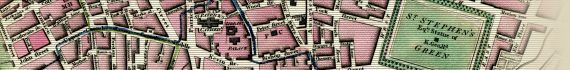
, Kildare Street, Leinster House, Kildare Place, Stable Lane, Upper Merrion Street, Merion Square, Lacys Lane, White Friar Street, Peters Row, Bishop Street, Upper Kevin Street, St Kevins Church, Long Lane, St Peters Church, York Street, Stable Lane, French Street, Digges Street, Redmond Hill, Cheaters Alley, Stable Lane, Cuffe Street, Kevins Port, Montague Street, Camden Street, Harcourt Street, St Stephens Green, Equestrian Statue Of King George IInd, St Stephens Green West, St Stephens Green North, St Stephens Green East, St Stephens Green South, Merion Row, Baggot Street, Hume Street, Ely Place, Leeson Street, Pembroke Street, & Fitzwilliam Square")


